
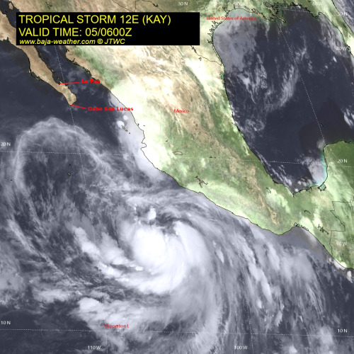
Kay continues to strengthen. Interests in the Baja California peninsula should closely monitor the progress of Kay.
Watches may be required for portions of the Baja California peninsula later today.
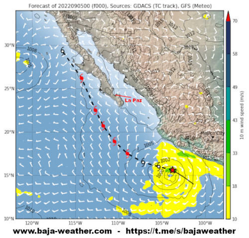
At 04:00hr CDT (09:00 UTC), the center of Tropical Storm Kay was about 380km (235 mi) SSW of Manzanillo, Mexico and about 935km (580 mi) SSE of the southern tip of the Baja California peninsula.
Kay is moving toward the west-northwest near 24 km/h (15 mph). This motion with some reduction in forward speed is expected through tonight.
A turn to the northwest and north-northwest is forecast to occur on Tuesday. On the forecast track, the center of Kay is expected to pass south and southwest of southwestern Mexico today and tonight, then move toward the southern Baja California peninsula on Wednesday.
Maximum sustained winds have increased to near 60 mph (95 km/h) with higher gusts. Additional strengthening is expected, and Kay is forecast to become a hurricane Monday night or early Tuesday.

Continued strengthening is forecast through midweek while it moves northward toward the Baja California peninsula later this week.
While the details of the long-range track and intensity forecasts are uncertain, there is increasing risk of wind and rainfall impacts in the Baja California peninsula during the middle and latter parts of the week.
Tropical-storm-force winds extend outward up to 335 km (205 miles) primarily to the northeast of the center.
Surf: Swells generated by Kay are likely to cause life-threatening surf and rip current conditions. These swells are expected to reach the southern portion of the Baja California peninsula by Tuesday.
Rainfall: Kay is expected to produce 3 to 6 inches of rainfall, with isolated storm total amounts of 10 inches, across portions of the Mexican Riviera and western Mexico through Wednesday night. These rainfall amounts could lead to flash flooding, including landslides.
Join the Baja Weather Channel here…

